What is sandpiper?
Forecasting how our environment will change into the future requires the scientific community to understand the processes that shape Earth’s surface environments through time. To do this, geoscientists collect images of Earth with satellites, run simulations, and test hypotheses with laboratory experiments. All of these methods improve our understanding of landscape change, but scientists using each of these tools struggle to bring their research together to make new insights.
sandpiper is a framework of interoperable hardware and software tools that enables research products from different teams and approaches to integrate with one another more easily than ever before. Major efforts of the project team include
- designing and implementing an affordable open-source hardware-firmware system for data acquisition
- forging a community-backed data standard
- developing a flexible and interoperable data-analysis software library
- establishing a sustainable community of practice.
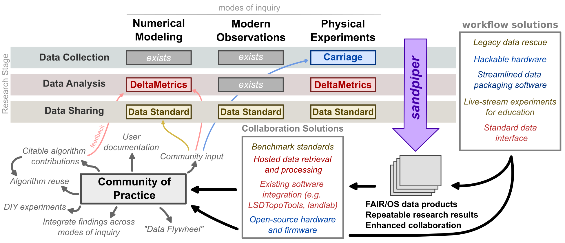
sandpiper framework. By combining existing mature elements that serve
geomorphology (grey boxes) with our planned improvements (colored boxes) and sandpiper integration.
Contributing
Interested in joining the effort? We are excited to bring on collaborators, users, developers, scientists, documentation-writers, idea-havers, and anyone else who wants to be a part of sandpiper. Ultimately, we are our community of users. Join us on GitHub by submitting a pull request or opening an issue!
Leadership team
- Charles Nguyen; University of Minnesota
- Andrew Wickert; University of Minnesota
- Eric Barefoot; University of California, Riverside
- Andrew Moodie; Texas A&M University
- Eric Hutton; University of Colorado, Boulder
Additional information on sandpiper toolchain governance, as well as individual project governance, can be found at github.com/sandpiper-toolchain/governance.
Funding support
The sandpiper toolchain is supported by the National Science Foundation, Directorate for Computer and Information Science and Engineering, Office of Advanced Cyberinfrastructure (OAC), and the GEO CI - GEO Cyberinfrastrctre, National Discovery Cloud for Climate Opportunities, Crosscutting Activities, Geomorphology & Land-use Dynamics, and Software Institutes programs.
Awards #2411033, #2411034, #2411035, and #2411036.
![]()